

In 2023 New Zealand’s largest city Auckland experienced two extreme weather events. Weeks of heavy rain culminated in tropical Cyclone Gabrielle in February 2023, the costliest event of its kind recorded in the Southern Hemisphere, causing damage estimated at NZ$14.5 billion.
Some of that damage was to New Zealand’s road network, and the roads managed by Auckland Transport recorded more than 2000 landslides.
As the organisation responded to this damage, it collected detailed information during the response and recovery processes, and then used the data to build a new landslide susceptibility framework.
“Prior to this study Auckland Transport asset management was done on a repair and maintenance basis of the network after storm events, and there was little information to support preventative forward works,” says Dr Cathy Bebelman, the Chief Scientist, at Auckland Transport.
“We used that data to create a framework that would allow us to predict whether a particular piece of road on our 8,000 kilometres of road network was susceptible to landslides.”
The Auckland Transport Science and Sustainability Group collaborated with geotechnical company Tetra Tech Coffey. Using the detailed landslide information, they developed the framework which allows asset management practices to adapt to the changing climatic conditions and improve the resilience of the road network.
“We used about 30 different factors which influence landslides to create that framework, and we tested and refined it using the data from the 2000 landslides we experienced during those storm events,” says Bebelman. Data was obtained from various open-source platforms, and Python scripts were developed to automate the collection of geospatial data, slope angles, embankment and cut dimensions, geological information, existing structures, overland flow paths, and fault lines.
“We then used Artificial Intelligence to roll out that framework across road network and turned it into a GIS layer which tells us where there is a low or a high risk of landslide.”
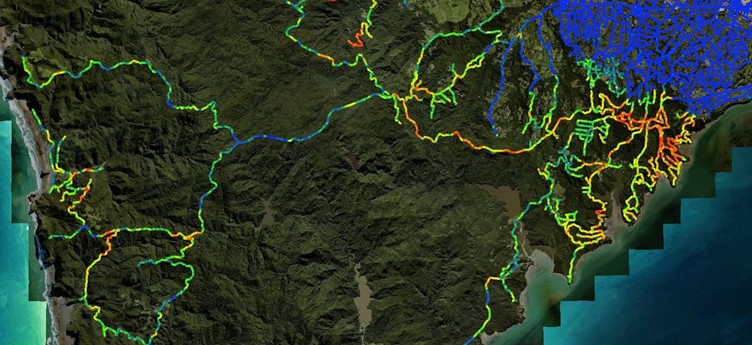
This was then extrapolated across the wider road network to predict landslide risks under future significant rainfall event scenarios.
To achieve this GIS layer, cross-sections were generated at 12.5 metre intervals along the 8000km of road network.
The framework can now be interrogated to deliver insights on the main factors contributing to landslide risk, giving Auckland Transport the opportunity to pre-empt landslide events through pro-active asset management.
“The framework gives us a picture of the level of risk,” says Bebelman. “We can look at a particular location and ask, of those 30 factors what are the top three which contributed to the risk rating.
“It might be things like the drainage running across the road, or it might be the slope, or the lack of vegetation, and there may be an opportunity through our forward works programme to do some preventative work.”
After spending around two and a half years restoring the damage, Auckland Transport is looking at how the framework can help protect locations and prevent damage in the future as part of its maintenance and renewals program.
“This approach aims to significantly reduce disruption and repair costs associated with future extreme weather events, ultimately enhancing the resilience of Auckland’s transport infrastructure,” says Bebelman.
“The framework is now utilised to support asset adaptation planning for future climate hazards.”
The insights are also informing engagement with communities which might be at risk.
“We can identify roads that are at high risk and provide this information to Council and local communities,” says Bebelman.
“Of course we will do what we can with funding, as it permits, to prevent future damage but now we have a better idea of the factors we can’t change, such as geology, and that enables us to understand the choices.”
“It is possible that a lower level of service might be acceptable for the next 10 or 20 years, and that an alternative longer-term solution might need to be found in consultation with Council and the community,” says Bebelman.
Dr Cathy Bebelman will be presenting the Auckland Transport Landslide Susceptibility Framework as part of the Asset Management Stream at IPWC 2025, to be held at ICC Sydney from 25-28 of August.
Chris Armstrong from Tetra Tech Coffey will also be presenting the technical aspects of the framework at a separate IPWC session.


